
Arizona Climate Zones and their Application to Growing Plants
Este material también está disponible en español.
Plants grow best in climates to which they are most adapted. Knowing the climate zone of a location is one of the factors to successfully cultivate plants outdoors. While soil, water, and light are critical, low or high temperatures can limit plant growth in a certain location. Arizona is a large state spanning 335 miles east to west and 390 miles north to south with diverse climate zones. The climate is influenced by elevation which determines the high and low temperatures, and by rainfall which varies across the state. Rainfall ranges from 3 inches annually in Yuma, the southwestern corner of Arizona, to more than 30 inches in the mountain areas. Arizona’s climate is classified as arid or semi-arid because evapotranspiration, the combined loss of water from soil and plants in a location, is greater than the amount of rainfall the area receives.
Using climate zones
Climate zones are useful to understand the temperature limitations of a location and select appropriate plants for long-term successful plant performance. Microclimates and unseasonal low temperatures, such as an early freeze in fall before plants have hardened off or a late freeze in spring after plant growth or flowering has started, can cause damage although the minimum annual temperatures have not been exceeded. For plants to thrive continually in a location, other factors such as soil quality, water and fertilizer availability, light, wind, and exposure to extreme conditions will affect plant growth and health.
Arizona climate zones
Arizona’s climate is in part affected by three physiographic landforms, the Colorado Plateau, the Transition Zone, and the Basin and Range (Fig. 1). The Colorado Plateau rises to elevations of 5,000 to 8,000 feet and occupies the northern part of the state, except for a narrow strip along the northwest border. At its southern edge, the Colorado Plateau ends with the Mogollon Rim, a steep slope with drops of 2,000 to 3,000 feet. The adjacent Transition Zone, also known as the Central Highlands, is characterized by rugged mountains, and leads into the Basin and Range which occupies most of the lower elevation in the southern part of the state and an area along the Colorado River and to the north. Lowland desert with some mountain ranges dominate the Basin and Range with year-round warm climate at the lower elevations. The diverse geography within each landform, such as canyons, creates microclimates that can change drastically over a short distance.
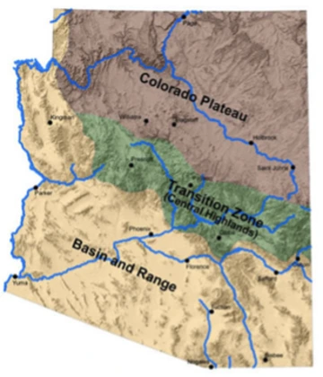
Fig. 1. Physiographic Provinces of Arizona. Photo credit: Arizona Department of Water Resources.
Climate zones refer to the long-term temperature and rainfall patterns that shape the natural vegetation in a geographic location. Landscapers, agronomists, and gardeners know how to select appropriate soils or how to change the soil conditions so they are favorable to the plants they cultivate. Irrigation is generally available to supplement rainfall. However, minimum and maximum temperatures outdoors cannot be changed and determine which plants can be cultivated successfully in a certain location. Three climate zone maps using different criteria are available for Arizona residents to choose suitable plant material for individual zones. The United States Department of Agriculture (USDA) Hardiness Zone Map (Fig. 2) classifies zones by minimum temperature. The American Horticulture Society (AHS) Heat Zone map uses the number of days above a threshold temperature, and the Sunset climate zones are defined by a combination of climate factors. Table 1 lists the three types of zones for the major cities in Arizona. Table 2 lists common landscape plants and their classification for the three climate zone maps.
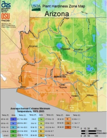
Fig. 2. USDA Plant Hardiness Zone Map for Arizona assigns zones based on the average annual minimum temperatures and ranges from zone 4b to 10b.
USDA Hardiness Zone Map (2012)
Is based on the average annual minimum winter temperature in a geographic location and is based on temperature records collected from 1976 to 2005. Zones range from 1 to 13 with 10-degree Fahrenheit increments. Further refinement is provided by dividing each zone into “a” and “b” subzones based on 5 degree increments. Zone 1 starts at -60°F and zone 13 applies to subtropical and tropical locations where minimum temperatures drop only to 50°F to 60°F. USDA Hardiness zones in Arizona range from 4b to 10b (Fig. 2). Coldest locations in zone 4b, where temperatures drop to -20°F to -25°F, include the San Francisco Peaks, the White Mountains, and Mount Graham. Residents of Flagstaff, Arizona live in zone 6a, where temperatures dip to -10 to -5°F and plant material needs to be hardy to these temperatures to survive. The warmest locations are located in the southwestern and southcentral part of the state, zone 10, mainly along the Colorado River and the Phoenix metropolitan area with minimum temperatures between 30°F to 40°F.
The USDA Hardiness zone map is available online. The quickest way to find the USDA hardiness zone of an area is the zip code finder. The interactive map of the website allows viewing a terrain, road, or satellite map of an area with optional layering of the maps. Pointing plus clicking to any location shows the zone, average minimum temperature, temperature range of the zone, and latitude and longitude. The interactive map was constructed using grid cells with a size of half a mile. This detailed information is especially valuable where rapid elevation changes occur over short distances and result in changes in climate zones.
The USDA Hardiness Zone map delivers great accuracy for Arizona regarding the minimum temperatures we can expect based on recent 30 year averages. This is useful in selecting well-adapted plant material for a location. Selection of marginally hardy plant material grown outdoors needs to be carefully matched to the expected minimum temperatures. Microclimates are affected by their immediate surroundings and are often warmer in urban areas where heat is absorbed, stored, or reflected, and colder in areas where strong temperature inversions occur, especially along rivers and washes.
Plant species are assigned USDA hardiness zones based on trials of growing plants in different regions. Long-term survival in the coldest zone a given species was evaluated in earns the species the rating for that zone. These trials are carried out by botanical gardens, nurseries, and different organizations involved in plant research. There is no single source where the USDA hardiness zones of plants are published. This information can be found in horticulture books, nursery catalogs, and many websites providing plant descriptions. It is common to find slightly different USDA hardiness zones for one species when different entities tested the plant. New species and cultivars entering the market are generally tested in several locations to inform consumers about the minimum temperatures these plants can tolerate.
When it comes to hardiness, cold is only one extreme plants experience during the year. USDA zones 9a and 9b common in southern Arizona also occur along the Oregon Coast and on the tip of the Olympic Peninsula in Washington. However, we know not to choose plants that thrive in those coastal regions because plants in southern Arizona are exposed to large daily fluctuations in temperature, low humidity, and extremely high summer temperatures which can be more stressful than low winter temperatures. For nurseries, landscapers, and gardeners in the Southwest, the Sunset climate zones are the most comprehensive source to use for choosing plant material that is well adapted to the vagaries of desert climate.
Sunset climate zones
Consider all aspects of climate such as latitude, high and low temperatures, elevation, ocean or continental air influence, and humidity. Plant growth is also affected by the length of the growing season, first and last frost date, and the annual pattern and amount of rainfall which is incorporated into the Sunset climate zones. Maps of the climate zones are available online.
The warmest locations in Arizona are assigned Sunset climate zone 13, the low or subtropical desert areas. This covers elevations up to 1,100 feet and includes the Phoenix area to Yuma, and land along the Colorado River. Average summer temperatures reach 107°F, but up to 15 nights of freezing temperatures, mostly in December and January, limit the plant palette. Tender subtropical plants can survive the freezes if they grow in protected locations, depending on the plant species, lowest temperature, and duration of freezing. Zone 12, the intermediate desert has on average 5 more freezing nights than zone 13, but with lower temperatures and over a longer period of time. Summer temperatures are about 5°F cooler than in zone 13. When growing deciduous fruit trees that require winter chilling (a minimum number of hours of temperatures between 45°F and 32°F) in zone 12 or 13, select varieties having a low chilling requirement (less than 300 hours) to ensure a good crop every year. Subtropical plants in zone 12 need to be tolerant of cold temperatures. Cool season vegetables are grown most successfully in both zones from September to late spring.
Sunset climate zone 10, the high desert areas of Arizona and New Mexico, applies to locations 3,300 to 5,000 feet in elevation. In this zone 75 to 100 nights of freezing temperatures occur and extreme lows of -10°F have been recorded. The growing season is approximately 7 months from early April until early November. Zone 3A, the mild areas of mountain and intermountain climates, is found around Prescott and east of Flagstaff to New Mexico. The growing season extends from May to mid- October and average winter minimum temperatures range from 15°F to 25°F. Zone 3B, the mildest areas of the intermountain climates is represented with a small area in Southeast Arizona and around Tuba City in the northern part of the state. This zone is similar to zone 3A with slightly warmer winters, warmer summers, and a growing season about one month longer.
Zone 2B, the warmer-summer intermountain climate, is prominent in the area of the Colorado Plateau and some mountains in Southeast Arizona. The warm growing season lasts from May to September and average minimum temperatures in winter are from 12°F to 22°F. The coldest zones in Arizona are 2A and 1A and are found at the highest elevations in the state. Long, snowy winters and brief growing seasons restrict the plant palette to hardy evergreens, some deciduous woody plants, and herbaceous perennials.
The Sunset Publishing Company is the sole reference authority assigning specific climate zones to a plant. Their designations are based on the input of many experts and are regularly updated and expanded with additional plants. In addition to the climate zones, individual plant descriptions have information about light and irrigation requirements.
Plant Heat Zone Map
The Plant heat Zone Map was developed in 1997 by the American Horticultural Society (AHS) using daily high temperatures recorded by the National Weather Service from 1974 to 1995. The 12 zones of the heat zone map are classified based on the number of heat days with temperatures above 86°F (30°C), which assumes (sometimes incorrectly) that plants begin to experience serious heat stress or cell damage above this temperature. Zone 1 has less than one heat day and zone 12 has more than 210 heat days.
In Arizona, heat zones span from zone 4, with more than 15 to 30 heat days at the high elevations in the north, to zone 11 with more than 180 to 210 heat days. Most of the area of the Colorado Plateau and the Transition zone are classified as zones 4 to 8 with more than 14 to 120 heat days. Heat zones are relevant for plants that suffer from heat stress above the threshold temperature. However, many plants native or adapted to the Arizona low elevation climate are desert plants that thrive when temperatures are well above 86°F on a daily basis.
Heat zone classifications of plants are found in the Heat Zone Gardening reference book (see References: Cathey, 1998) and are based on the adaptability of plants to summer heat and optimum performance. This means that plants can grow acceptable in warmer or cooler heat zones, but not necessarily with top performance. Heat zones are assigned only to the genus, not individual species, although most descriptions use species or cultivar examples in their description. Heat zone classification of plants has not been updated or expanded since the publication of the original reference book in 1998 and does not cover many plants relevant for Arizona landscapes.
Table 1. Cities in Arizona and their classification according to the USDA Hardiness Zones, the Sunset Climate Zones, and the AHS Heat Zones.
| City | USDA Hardiness Zone | Minimum Temperature (°F) | Sunset climate zone | Sunset zone description | AHS Heat Zone | No. days above 86°F |
|---|---|---|---|---|---|---|
| Flagstaff | 6a | -10 to -5 | 2B | Warmer summer intermountain climate | 2 | 1 - 7 |
| Show Low | 7a | 0 to 5 | 2B | Warmer summer intermountain climate | 4 | 15 - 30 |
| Prescott | 7b | 5 to 10 | 3A | Mild mountain and intermountain climates | 6 | 46 - 60 |
| Tuba City | 7b | 5 to 10 | 3B | Mildest mountain and intermountain climates | 8 | 91 - 120 |
| Willcox | 8a | 10 to 15 | 10 | Arizona - New Mexico high desert | 9 | 121 - 150 |
| Bisbee | 8a | 10 to 15 | 10 | Arizona - New Mexico high desert | 6 | 46 - 60 |
| Sedona, Sierra Vista, Camp Verde, Page, and Kingman | 8b | 15 to 20 | 10 | Arizona - New Mexico high desert | 8 | 91 - 120 |
| Safford | 8b | 15 to 20 | 12 | Arizona’s intermediate desert | 9 | 121 - 150 |
| Globe | 9a | 20 to 25 | 10 | Arizona - New Mexico high desert | 7 | 61 - 90 |
| Casa Grande | 9a | 20 to 25 | 12 | Arizona’s intermediate desert | 11 | 181 - 210 |
| Tucson | 9b | 25 to 30 | 12 | Arizona’s intermediate desert | 10 | 151 - 180 |
| Phoenix Metro | 9b | 25 to 30 | 13 | Low or subtropical desert | 10 | 151 - 180 |
| Ajo | 10a | 30 to 35 | 12 | Arizona’s intermediate desert | 11 | 181 - 210 |
| Bullhead City, Lake Havasu City, and Yuma | 10a | 30 to 35 | 13 | Low or subtropical desert | 11 | 181 - 210 |
Landscape materials and hardiness zones
Table 2. Commonly used landscape plant materials used in Arizona and their classification according to US Department of Agriculture Hardiness Zone, Sunset Climate Zone, and American Horticulture Society Heat Zone.
Trees
| Latin Name | Common Name | USDA Hardiness Zone1 | Sunset Climate Zone2 | AHS Heat Zone3 |
|---|---|---|---|---|
| Acacia farnesiana | Sweet acacia | 9 - 11 | 8, 9, 12 - 24 | 12 - 1 |
| Acacia stenophylla | Shoestring acacia | 9 - 11 | 8, 9, 12 - 24 | 12 - 1 |
| Acer x freemanii | Freeman maple | 3 - 9 | 2A, 3A, 1 - 9, 14 - 17 | 10 - 3 |
| Catalpa bignonioides | Southern catalpa | 5 - 9 | 3 - 10, 14 - 24 | - |
| Celtis reticulata | Western hackberry | 5 - 13 | 2 - 24, best in 2, 3, 7 -13, 18 - 21 | - |
| Cercis occidentalis | Western redbud | 7 - 9 | 2 - 24 | 12 - 9 |
| Chilopsis linearis | Desert Willow | 7 - 11 | 3B 7 - 14,18 - 23 | 11 - 7 |
| Chitalpa tashkentensis | Chitalpa | 6 - 11 | 3 - 24 | - |
| Cupressus arizonica | Arizona cypress | 7 - 9 | 7 - 24 | 9 -3 |
| Dalbergia sissoo | Indian rosewood, Sissoo | 9, 10 - 11 | 13, 19, 21 - 24 | - |
| Ebenopsis ebano | Texas ebony | 8 - 11 | 12, 13 | - |
| Ficus carica | Fig, edible | 8 - 11 | 4 - 9, 11 - 24 | 12 - 1 |
| Fraxinus pennsylvanica | Green ash | 3 - 9 | 1 - 6 | 8 - 2 |
| Fraxinus velutina | Arizona ash | 7 - 11 | 3B - 24 | 8 - 2 |
| Juglans major | Arizona walnut | 4 - 9 | 10 - 13 | - |
| Juniperus deppeana | Alligator juniper | 7 - 9 | 1 - 3, 10 - 12 | 9 - 1 |
| Malus sp. | Flowering crabapple | 4 - 8 | 1 - 11, 14 - 21 | 8 - 2 |
| Parkinsonia florida | Blue palo verde | 8 - 11 | 8 - 14, 18 - 20 | - |
| Phoenix dactylifera | Date palm | 9 - 11 | 8, 9, 11 - 24 | - |
| Pinus eldarica | Afghan pine | 6 - 11 | 6 - 9, 11 - 24 | - |
| Platanus wrightii | Arizona sycamore | 7 - 11 | 10 - 12 | - |
| Prosopis glandulosa | Honey mesquite | 10 - 11 | 10 -13, 18 - 24 | - |
| Prosopis velutina | Velvet mesquite | 9 - 11 | 10 -13, 18 - 24 | - |
| Quercus arizonica | Arizona white oak | 3 - 9 | - | - |
| Quercus buckleyi | Texas red oak | 6 - 11 | 3B, 6 - 12, 18 - 22 | - |
| Quercus virginiana | Southern live oak | 7 - 10 | 4 - 24 | - |
| Robinia neomexicana | New Mexico locust | 6 - 9 | 2, 3, 7 - 11, 14, 18 - 24 | - |
| Washingtonia filifera | California fan palm | 9 - 11 | 8, 9, 10, 11 - 24 | - |
| Washingtonia robusta | Mexican fan palm | 9 - 11 | 8, 9, 10, 11 - 24 | - |
Schrubs and accent plants
| Latin Name | Common Name | USDA Hardiness Zone1 | Sunset Climate Zone2 | AHS Heat Zone3 |
|---|---|---|---|---|
| Agave americana | Century plant | 9 - 11 | 10, 12 - 24 | 12 - 5 |
| Agave parryi | Parry’s agave | 9 - 11 | 2B, 3, 6 - 24 | 12 - 5 |
| Atriplex canescens | Four-wing saltbush | 6 - 10 | 1 - 3, 7 - 24 | 12 - 5 |
| Caesalpinia gilliesii | Bird of paradise | 9 - 11 | 8 - 16, 18 - 24 | - |
| Caesalpinia pulcherrima | Red bird of paradise | 9 - 11 | 12 - 16, 18 - 23 | - |
| Calliandra californica | Baja fairy duster | 9-11 | 12-16,18-23 | - |
| Cornus stolonifera | Red-osier dogwood | 3 - 8 | 1 - 9, 14 - 21 | 9 - 1 |
| Carnegia gigantea | Saguaro | 9 | 12, 13, 18 - 21 | - |
| Dasylirion wheeleri | Desert spoon,Sotol | 8 - 10 | 10 - 24 | - |
| Ferocactus spp. | Barrel cactus | 9 - 11 | 8 - 24 | - |
| Forsythia x intermedia | Forsythia | 4 - 8 | 2B - 11, 14 - 16, 18, 19 | 8 - 4 |
| Fouquieria splendens | Ocotillo | 8 - 10 | 10 - 13, 18 - 20 | - |
| Juniperus spp. | Juniper shrubs | 2 - 9 | 1 - 24 | 9 - 1 |
| Hesperaloe parviflora | Red yucca | 8 - 10 | 2B ,3, 7 - 16, 18 - 24 | - |
| Larrea tridentata | Creosote | 8 - 10 | 7 - 14, 18 - 21 | - |
| Leucophyllum spp and varieties | Texas ranger | 8 - 11 | 7 - 24 | - |
| Ligustrum vulgare | Privet | 7 - 10 | 2 - 24 | 9 - 1 |
| Nerium oleander | Oleander | 8 - 10 | 8 - 16, 18 - 24 | 12 - 1 |
| Opuntia spp. | Prickly pear | 3 - 11 | 12 - 24 | - |
| Punica granatum | Pomegranate | 8 - 10 | 5 - 24 | 12 - 5 |
| Rhus ovata | Sugar bush | 7 - 11 | 9 - 12, 14 - 24 | 9 - 5 |
| Vauquelinia californica | Arizona rosewood | 8 - 10 | 10 - 13 | - |
| Vitex agnus-castus | Chaste tree | 7 - 11 | 4 - 24 | 10 - 1 |
| Yucca baccata | Banana yucca | 5 - 11 | 1 - 3, 7, 9 - 14, 18 - 24 | 9 - 1 |
1 The following references were used for USDA plant hardiness and were accessed on 3/2/2015:
http://hort.ifas.ufl.edu/woody/selection.shtml
http://selectree.calpoly.edu/
http://oregonstate.edu/dept/ldplants/
https://ag.purdue.edu/pages/default.aspx
http://plants.usda.gov/java/ http://extension.usu.edu/
http://aggie-horticulture.tamu.edu/ornamentals/nativeshrubs/
http://www.missouribotanicalgarden.org/
http://redwood.mortonarb.org/
2 Only Sunset climate zones from the continental US are listed, Alaska and Hawaii zones are not included.
3 AHS heat zones are given only for the genus.
References
Agricultural Research Service, U.S. Department of Agriculture. 2012. USDA Plant Hardiness Zone Map. http:// planthardiness.ars.usda.gov. Accessed 2/25/2015.
American Horticulture Society. Heat Zone Map. http://www.ahs.org/gardening-resources/gardening- maps/heat-zone-map. Accessed 3/2/2015.
Arizona Department of Water Resources. Physiographic provinces of Arizona. www.azwater.gov. Accessed 3/2/2015.
Brenzel, K.N. 2012. The New Sunset Western Garden Book, 9th Ed., Time Home Entertainment Inc. New York, New York.
Cathey, H.M. 1998. Heat-Zone Gardening: How to Choose Plants that Thrive in your Region’s Warmest Weather. Time-Life Inc., New York, New York.
Sunset. Sunset climate zones. http://www.sunset.com/ garden/climate-zones. Accessed 3/2/2015.